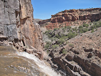
Gunnison River- Whitewater (class II+)
Length: 26 miles
Difficulty: class II+
Gradient: 6'/mile
Put-in: Escalante Bridge
Takeout: Whitewater
This scenic run is one of the most mellow sections of the Gunnison and is well worth the paddle for a beginner or anyone who wants to get off the beaten path. Though there are several major highways nearby, and this is not wilderness by any stretch, there is a very quaint and remote feel to the run. Dominguez Canyon is about halfway into the run and well worth exploring. There is a beautiful, 30 foot waterfall a few miles up this remote side canyon.
 |
| Dominguez side hike |
-------------------------------------------------------
MODERATE
Roaring Fork River- Slaughterhouse (class IV)
Length: 4.5 miles
Difficulty: class IV
Gradient: 80'/mile
Put-in: Cemetery Lane
Takeout: Upper Woody Creek Bridge
 |
| Slaughterhouse Falls |
The Slaughterhouse Run on the Roaring Fork River is one of the best class IV runs on the Western Slope and in the entire state of Colorado. The rapids are exciting, mostly clean, but not overly taxing and the rural setting is generally excellent. While the first half mile contains some of the most infamous whitewater with Entrance Exam and Slaughterhouse Falls, quality and challenging whitewater are found without. In fact, after you enter Entrance Exam just below the put-in, the river hardly lets up for the entire duration of the run until the takeout four and a half miles later. Some of the rapids found in the lower half of the run, such as S-Turn, Triple Drop and Hawaii Five-O can all be considered the crux of the run depending on the flow of the river.
Getting There
Slaughterhouse is accessed off Highway 82 just north of Aspen. The put-in is found at a traffic light just as you are leaving town. Turn right onto Cemetery Lane and follow the road down to the river. The put-in is at a small park just downstream of the bridge on river right. The takeout is just upstream of the Upper Woody Creek Bridge on river right. You can get there by either continuing past the put-in until Cemetery Lane turns into McClain Flats road and following that all the way until you reach the Upper Woody Creek Bridge, or from Highway 82 by turning east at a sometimes hard-to-spot sign marking "Woody Creek Canyon". NOTE: there are two signs that say "Woody Creek Canyon". This is the upstream of the two.
--------------------------------------------------
EXPERT
Crystal River- Crystal Gorge (class V+)
Length: 2 miles
Difficulty: V+
Gradient: 350'/mile
Put-in: Clearing upstream of Marble
Takeout: Beaver Lake (see text)
The Crystal Gorge is one of Colorado's premier creek runs. It is short, steep and intense and only to be attempted by top expert creek boaters and only then at very low levels. Once considered the utmost fringe in kayaking difficulty, and graded class VI in the original Colorado Rivers and Creeks, the Crystal Gorge has become a benchmark for Colorado hair boating. And for good reason: the whitewater is hard and dangerous. The inner gorge is particularly menacing and if you don't properly do your homework you could be getting yourself into serious trouble down there. The last few drops of the inner gorge are plainly unrunnable and washing into them by mistake could mean bye bye. Scout well and/or go with someone who knows the run well.
Getting There: The Crystal Gorge is accessed past the town of Marble six miles off Highway 133 south of Carbondale. The takeout is at Beaver Lake, which the road traverses around. The put-in is a bit farther after a long, bumpy hill. Passenger cars may have trouble getting up this hill.
Check out the helmet-cam video guide to the Crystal Gorge featured on our video gallery page right now.

No comments:
Post a Comment